Exploring the wonders of geology in response to young-Earth claims...

Never been here? Please read my guidelines and background posts before proceeding!

Thursday, November 1, 2012

The "Evolution of creationism" hits the front page in geological circles

The most recent issue of GSA Today, published by the Geological Society of America, featured an article by University of Washington Professor of Geology David Montgomery, entitled "Evolution of Creationism". Therein, Dr. Montgomery summarized the generally symbiotic growth of faith and science over the past centuries--particularly in geology. He emphasizes that before the most recent era, one could not polarize the two in academic arenas. Surprising to most readers will be that the modern Young-Earth Creationist movement represents only a relatively recent development in evangelicalism, which does not characterize previous centuries of believers.

Dr. Montgomery's article covers a most pertinent topic and should contribute positively to the discussion today. On the one hand, it offers a brief but highly informative history of the church's response to scientific discovery in the Earth sciences. This history has been documented at length in works such as Saving Darwin by Karl Giberson and The Biblical Flood: A Case Study of the Church's Response to Extrabiblical Evidence by Davis Young. However, Montgomery brings it to a new arena in a more palatable form. Now, nearly every geology/geography professor in the United States will be exposed to six pages of a far more balanced and accurate portrayal of creationism in America than the occasional courtroom fiasco, reckless politician, or Gallup poll has to offer. My personal hope is that geologists in academia will have a fresh understanding of why YEC is so prominent in America, and how better to address it in and out of the classroom. Montgomery's own suggestion is simply to teach a history of creationism proper, which he speculates few modern YEC's actually know (and I concur). He concludes the article by posing this critical question:

"How many creationists today know that modern creationism arose from abandoning faith that the study of nature would reveal God’s grand design for the world?"

If you are interested in reading the full article, it is currently available (for free!) online at the GSA Today main page (November 2012 issue). I highly suggest you read it in its entirety. Also, feel free to leave any comments here for further discussion. For example, what did you think of his portrayal of reason, faith, and the church's historical stance toward scientific study of the Earth? If you should have any trouble accessing the page/files, please contact me.

Dr. Montgomery's personal interest in the biblical flood and how it relates to the history of geology was also summarized in a recent TED talk (follow this link). It goes without saying that I would endorse the following advice from that presentation:

"I can't help but to think that portraying a fundamental conflict between science and religion is particularly dangerous today now that we really need new, creative solutions to basic social and environmental problems, if we're going to maintain civilization..."

What do you think?

Wednesday, October 31, 2012

Disconfirming a Young Earth: Introduction

It appears Dr. Snelling is back, this time in a 10-part summary of the "Best Evidences from Science that Confirm a Young Earth".

The mere rhetoric of this title leads one to great expectations. "Aha!" rejoices the Young-Earth optimist. "Now my friends and colleagues will see that science is, fundamentally, on my side." Like a herd of cheerful smokers that naïvely glossed over the warnings in health class, perhaps we 'Old-Earthers' might also kick the habit after seeing all the evidence laid out against us. And besides, we are not promised mere 'proof-texting' of nature's Bible in support of a Young-Earth. These ten examples are, according to Answers in Genesis, the best—the most convincing—that science has to offer.

Not surprisingly, however, Dr. Snelling offers little more than a novel arrangement of quite old retorts—most of which I learned to recite as a teenager. Age is no indicator of truthfulness—neither in philosophy nor in science. But I raise this point to suggest that Dr. Snelling's arguments are outdated, in that they are unmodified despite longstanding criticisms. As long as the kind folks at Answers in Genesis isolate their claims from peer review, they undermine their ability to make meaningful academic claims.

Furthermore, Dr. Snelling's arguments are unscientific and illogical in at least two ways. First, the claim that these evidences confirm (i.e. they are consistent with) a young Earth rests in tautology. In each case, Dr. Snelling (or cited authors) will define the physical data according to a Young-Earth timeline and then pronounce the data as being consistent therewith.

No method is said to corroborate a 6,000-year age of the Earth independent from the starting assumption that the Earth is 6,000 years old.

In other words, the evidence from science confirms a young Earth, because we have made it to do so. There is no room for surprise; we are right because we are right. If you don't already agree fully with Dr. Snelling's ideological claims, don't expect to be challenged by the evidence he cites.

Secondly, I will suggest that Snelling's approach is philosophically inconsistent. Answers in Genesis is infamous among critics for distinguishing falsely between operational and historical science (or for radicalizing that distinction). In reality, these two aspects of science represent two faces of the same methodological approach. So called operational science seeks to interpret the repeatable results of a designed experiment. In the historical sciences, however, the experiment has already been run by nature, so to speak. It is the unobserved 'experiment' that must be interpreted and reconstructed through testing of competing hypothetical scenarios (hypotheses), which seek to explain the observed results. Both aspects of science involve observations and assumptions, and neither is independent from ideological or hermeneutical biases. Therefore, both are fluid and highly susceptible to scientific revolutions.

By delineating sharply between operational and historical science (the latter of which contradicts their claims), Answers in Genesis has conspicuously lent credence to one over the other. To be credible, historical sciences must be guided by an eyewitness account from someone who saw or even designed the experiment. That eyewitness account, they claim, is received through the textual tradition of the Hebrew Bible. The unspoken irony is that understanding the Bible requires an appeal to the historical sciences—namely, literary hermeneutics applied to ancient texts.

Notwithstanding your own view on the divine inspiration of the Bible, you should be able to recognize the logical errors being made. With a little simmering, we can reduce AiG's stance to the following:

    1) Historical science is full of untestable assumptions and is therefore not trustworthy without appealing to our authoritative interpretation of divine scripture. If your historical inquiry contradicts ours, then your starting assumptions must be false, because ours alone are correct. We know they are correct, because they are consistent with our interpretation of divine scripture, which itself appeals to the historical sciences. Our appeal to the historical sciences is correct because it is guided by our interpretation of divine scripture. (Another tautology that results in begging the question)

    2) Nonetheless, here are ten evidences derived from historical science that confirm our claims. Of course, these evidences are only sensible if interpreted according to our view of history. Historical science is reliable when it supports our claims, therefore, but not when it contradicts them. (A philosophical inconsistency)

Over the next few posts, I will briefly analyze Dr. Snelling's Top Ten list of scientific evidence confirming a young Earth. Is there too little sediment on the seafloor to believe in an 'old' Earth? Too little salt in the ocean? What about soft tissues that survived fossilization? Although these are commonly raised objections by YEC's to an old Earth, very few know how these 'evidences' are compiled in the first place. But therein the magic is found. Numbers don't lie, but people often lie with numbers.

Fortunately, we need not get technical to reveal the magician's secret.

Wednesday, October 17, 2012

Geology of Northwestern Russia: a brief photo tour (Part 2)

Well, I did not intend to wait two weeks to finish this story, but a trip to Moscow—among other responsibilities—delayed my getting back to the topic. I am still amazed at how quickly time moves here!

In this post, I want to finish the timeline by discussing how this region of Russia transitioned from ice age to the modern warm period. If you are interested in how the story beings, please see Part 1 in my previous post.

Figure 1: Map of northwestern Russia with sites of interest, and geographical and political boundaries. Major water bodies are the Gulf of Finland at the top left and Lake Ladoga at the top right. The city of St. Petersburg (Санкт-Петербург) is located on the delta of the Neva River, which feeds the gulf from the east.
Around 21,000 years ago, the Scandinavian Ice Sheet extended to the hills of Valdai (Fig. 1), where morainal (Fig. 9; last post) and proglacial sediments are still found at the surface. Thus it is no surprise that the modern topography—its plains, ridges, lakes and rivers—are defined entirely by the advance and degradation of this monstrous block of moving ice. And yes, it is vital to emphasize that glacial is constantly moving, albeit at inches per year.
Figure 2: Valley lowlands outside of Velikiy Novgorod, where a few thousand feet of ice flattened the landscape and left it bare.
As a result, the Earth's surface is scratched, twisted, or smoothed out (Fig. 2) while the ice sheet samples rocks and sediments across its entire journey, much like an obsessed traveller stopping at every gift shop for representative collectibles. In fact, some of the more successful attempts to estimate the average chemical composition of the Earth's crust merely involved analyzing clays that accumulated at the edge of glaciers. Glaciers are nature's most meticulous geologists, in that sense.

Figure 3: Southern coast of Lake Ilmen; view from atop the glint (limestone escarpment; see Fig. 3, last post).
Continental glaciers begin to retreat when the ice at their margin melts faster than ice can accumulate in higher latitudes. In other words, melting glaciers are not like stagnant ice cubes left out in the sun, but continue to flow even as they disappear. For northern Eurasia and Fennoscandia (as in North America), the disappearance of such ice took some 10,000 years, just to give you an idea of the volume of freshwater added to the continent. During the transition from the Late Glacial period to the early Holocene (~14,000–9,000 years ago), the climate of northern Eurasia also became substantially warmer and wetter. The contribution of glacial ice, melting permafrost, and enhanced precipitation was sufficient to raise the water levels of the Black Sea and Caspian Sea by tens of meters. In northwestern Russia, numerous lakes and rivers now fill depressions that formed under and between lobes of glacial ice, though most lakes have decreased in area since the Late Glacial period. Lake Ilmen (above and below) is a prime example.

Figure 4: Rocky shoreline of Lake Ilmen, which includes erratic boulders from northern granites.
Lake Ilmen basin developed in a proglacial setting, where it was fed by water and sediment from the ice sheet to the north. That Lake Ilmen was once much larger is evidenced by banded (varved) clay formations that extend far beyond the modern lake margin (Figs. 25-27, last post). Overlying these clays, stratigraphically, are thin-bedded sandy sediments that reflect a shallowing of the lake as the landscape and climate further evolved. During the Late Glacial period (14,000–11,500 years ago), the level of Lake Ilmen fluctuated in response to oscillating ice sheets, brief cooling and drying of climate, and the formation of a 'pre-Volkhov' channel that caused the lake to drain below modern level about 13,000 years ago.

Figure 5: Northwestern shore of Lake Ilmen. The lake itself covers a shallow depression, visible also by low-gradient shorelines on the northern edge. Between rainy and drought years, the area of the lake fluctuates by more than a factor of two.
Pollen and spores collected from these sediments tell their own story of lush forests and grassy meadows, which quite literally sprouted from the barren ground shortly after it melted. The relative abundance of pollen from grasses, herbs, and trees in lake sediments very precisely reflects the temperature and humidity of the surrounding region. By collecting pollen and spores from each layer, therefore, one can interpret how climate changed over time. As you might imagine, stratigraphic shifts in pollen abundances closely follow lake level (cold vs. warm climate), as well as oxygen isotope records from the North Atlantic ocean (also indicative of cool vs. warm climate). These records also generally agree with those from caves and loess in Eastern Europe, peat and lake formation in the Baltic region, and other proxies on land. Geologists and paleogeographers use these tools to reconstruct past climate changes region by region, as well as to deduce physical causes behind such changes.

Figure 6: A brief detour (fish on the Ilmen shore): contrary to YEC claims, it is possible to collect specimens for fossilization in sediments accumulating at modern rates. This half-buried fish (not to mention an abundance of shells) is a common site on lake shores, as scavengers are more interested in meat than bones. On the shore of the Great Salt Lake, I've even seen an entire bird skeleton buried under a few centimeters of lime sediment, which solidifies rather quickly. If this process was responsible for the bulk of fossils currently found in the geological record, then we might still predict that preservation is a rarity. But that is a far cry from "impossible" outside of "catastrophic conditions".
It is a curious challenge for the YEC, therefore, that proxies for Pleistocene and Holocene climate agree so well, given that each is dated by various methods (Radiocarbon, U-series, OSL, ESR, Beryllium-10, etc.) and reflects different geological processes. It is possible that in NW Russia, for example, a shift in pollen abundance from cold-weather herbs to an dominance of pine and oak trees (a sign of warmer and wetter climate) was not due to changing climate over thousands of years, but is rather an artifact of sediments from various regions being washed into a single lake basin (remember, the Flood can accomplish whatever one wants it to). I have heard YEC's argue in this manner, but one should ask: why does the radiocarbon method, applied to several dozen lakes in Russia alone, date this transition (which happened across Eurasia and North America) to approximately the same time period? Furthermore, why does the oxygen-isotope composition of calcite (from marine shells, carbonate lakes, or caves) record a similar transition at the same time, as defined by a completely different dating method (U-Th)?

Figure 7: Mouth of the Volkhov River, which connects Lake Ilmen to Lake Ladoga (another geomorphological remnant of the ice sheet). View from St. George Monastery—the oldest in Russia—in Velikiy Novgorod.
Put more simply, if radiometric dating doesn't work, then why does it work so well?

The physical theory by which dates from each method are interpreted from raw data have only time in common in their equations. In other words, there is no physical explanation besides the passage of time to explain why radiocarbon and Uranium-Thorium dates should agree with each other, since each dating method reflects a completely different process (the accumulation of radioactive carbon in the atmosphere versus the accumulation of thorium in crystalline calcite). The most parsimonious explanation is the one most commonly given: global and regional climates changed dramatically over the course of several thousand years during the transition from ice age (~21,000 years ago) to a warm early Holocene (~11,000 years ago).

Figure 8: Ducks! But not entirely unrelated to the glacial story. As ice melts from the land, many tons of pressure leave with it. This often cracks the frozen ground, forming new paths for groundwater to reach the surface. Highly mineralized water still bubbles to the surface and is the fount for this popular health resort at Staraya Russa, where Dostoevsky himself wrote part of The Brothers Karamazov and found inspiration for one of its characters.

Figure 9: Speaking of groundwater, this artesian aquifer was tapped accidentally by the advancing German army in World War II, when a shallow well pierced the overlying aquitard. Just west of Novgorod, this creek and a nearby monument to local Soviet soldiers mark the occasion's solemn memory.
And on to Velikiy Novgorod, which recently celebrated its 1153rd birthday. Novgorod is one of the oldest cities in the Russian territory, though it was not annexed to Russia officially until the reign of Ivan the Terrible (16th century). Novgorod owes its economic success to the process of deglaciation some 14,000 years prior. The numerous rivers that now feed or drain Lake Ilmen connect the Gulf of Finland/Baltic Sea to the Black Sea and the Caspian Sea—not to mention every city in between. This made Novgorod an ideal spot for Medieval tradesmen and merchants. Until the past few centuries, Novgorod rivaled cities like Paris, both economically and in terms of population. Even the peasants of Novgorod enjoyed a relatively high standard of living up through the Imperial period. I highly recommend this spot to any of you travelling to Eastern Europe, not only for its historical sites and architecture, but for the natural beauty that surrounds it.

Figure 10: In the "Square of Seven Churches", this one alone reveals the original brickwork. The original date of construction escapes me (13th century?), but the preservation is outstanding nonetheless. For most of its history, stone construction was not allowed in Novgorod except for churches. For that reason, the city burned down multiple times—well, all but the cathedrals.
Figure 11: Main bridge and gate to the Kremlin at Novgorod. Two more outer walls protected the city, as well as this innermost citadel, from invaders. This stronghold was also known as the "Detinets" (Детинец), which may also refer to the fetus of a mother. Fortunately, these walls never served a defensive purpose and still stand ~1,000 years later. The Novgorod Kremlin is also home to the oldest cathedral in all of Russia: St. Sophia's (follow link for more pictures of the cathedral and its art).
As one follows the retreat of the glacier back toward St. Petersburg, the Izhora Plateau stands out among the absolutely flat landscape. Bound on the north by a cuesta-like escarpment, the plateau diverts major rivers such as the Volkhov that flow north to Lake Ladoga or the Baltic Sea. The faulted and folded landscape of the Izhora Plateau is partially due to glacial sculpting, but much is a result of neotectonic deformation since the earliest stage of the Holocene. As a result, numerous springs flow from the fractured, Ordovician limestone bedrock. The rivers and lakes here are pristine and crystal clear (Fig. 22), while the vegetation is so green year round as to be therapeutic.

Figure 12: Entrance to a late Medieval fortress on the Izhora Plateau. Originally built by Germanic tribes in the 13th century, the stronghold was 'renovated' by Swedes in the 16th century.
Figure 13: The bricks here are derived from local limestone. A closer look would reveal numerous marine fossils from the Ordovician period. Thus construction began long before man tilled the land here. 
Figure 14: West wall; a daunting view for would-be attackers. 
Figure 15: View northwest toward the Baltic (from the other side of the tower in Fig 14). Endless forests conceal the rich soil. 
Figure 16: Up top, you can see that the stronghold is more of a walled, earthen mound. However, I wouldn't complain as a resident...
Figure 17: Not part of the original construction, this crumbling Russian Orthodox church reveals how the territory has shifted politically over the years.
Figure 18: And finally, a view from one of the defensive posts on the wall. Robin Hood, anyone?
During the early stages of the Holocene, the climate became substantially warmer until the Holocene Climate Optimum, about 6,000 years ago (or 16 years after creation, by YEC reckoning). One question that remains is how atmospheric circulation responded to warming in this region, and whether warming was accompanied by wetter or drier conditions. Carbonate lake sediments (Figs. 19–20) formed on the Izhora during the first half of the Holocene and may provide some clues.

Figure 19: Microdetrital carbonate sediments (beige-colored, carbonate sand) are exposed here in a local quarry. This rock had been used for more than 100 years for renovations in St. Petersburg and the surrounding area. Some of the quarried stone was even used to mend Kazanskiy Cathedral.
Figure 20: Closeup of carbonate sediments, this time cut for geological sampling. Annual layers are visible even at this distance. These layers formed as lake productivity fluctuated between summer and winter months, much like varves. Numerous shells of molluscs (mostly snails) tell their own story of how lake levels fluctuated during the early Holocene. The lake drained very near or before the Holocene Climate Optimum, and the valley is now cut by the modern Izhora River.
Although the prior existence of a lake that is no longer there may seem to imply wetter conditions, the formation of the lake actually resulted from structural deformation (small anticlinal folds) that dammed the river—not necessarily from more rain/snow. An alternative hypothesis is that this warm period was accompanied by more frequent anticyclonic circulation, which originates in the Arctic, blocks moisture from the North Atlantic, and causes severe drought. The fires around Moscow in Summer 2010 were the result of such circulation patterns. If future warming increases the frequency of drought, local agriculture may suffer accordingly. According to analyses of instrumental records over the past 250 years, the city of St. Petersburg has warmed by 1°C more than major cities of western Europe. Since the shorter, less productive growing season of Northwestern Russia is more sensitive to drought, this hypothesis needs to be resolved soon.

Figure 21: Ordovician limestone bedrock, responsible for the topography of the Izhora Plateau, as well as its rich soils.  This rock also hosts the cleanest groundwater of the region, including the springs that fed Peter the Great's summer palace. This picture is more for looks than anything, as it strongly contrasts the sort of outcrops I am used to seeing back home. 
Figure 22: Pristine and crystal clear lakes, as promised.
And thus ends my brief geological tale—scattered and disorganized perhaps as the political history of Russia. I will leave you only with two eerie markers of a more recent 'upturning' near the Izhora Plateau. Like those great sheets of ice, remnants of the Russian Revolution are ubiquitous and unmistakeable. That advancing wave erased some memories in favor of others and left much of the political and economic landscape bare, yet still fertile for growth and new ideas. Attitudes toward that era are still mixed among the populace, but it shaped this region no less than the walls of ice that preceded it by more than 20,000 years.

Figure 23: Lenin was far more than a cultural icon here. His image symbolized hope and freedom. 
Figure 24: For the most part, 'Noble' cottages like this one did not survive the 1917 revolution. With haunting scenes like this one dotting the landscape south of St. Petersburg, that year will long be fresh in the cultural memory.
Catching the last train home...

Saturday, September 29, 2012

Geology of Northwestern Russia: a brief photo tour (Part 1)

Figure 1: Northwestern Russia, with highlighted stops from this trip. For reference, the edges of the Gulf of Finland (top left) and Lake Ladoga (top right) are also visible, as well as the border with Estonia (left). The Izhora Plateau is located immediately southwest of the city of Saint Petersburg (Санкт-Петербург; top).
Recently, I toured a number of geological and historical sites between the suburbs of St. Petersburg and the Valdai Hills region. As one who lived and learned geology in semi-arid, mountainous regions of the American west, this trip offered a fresh look at surface geological processes, as well as a new appreciation for Quaternary geology. The Quaternary period spans the past 2.588 million years and includes the Pleistocene and Holocene epochs, but most research focuses on climatic and geographic changes during the latest Pleistocene "ice age" and the Holocene "interglacial" (11,500 years ago until present). Northwestern Russia contains many pristine records of both intervals and so is a frequented location for those wanting to reconstruct the past ~100,000 years of Earth history.

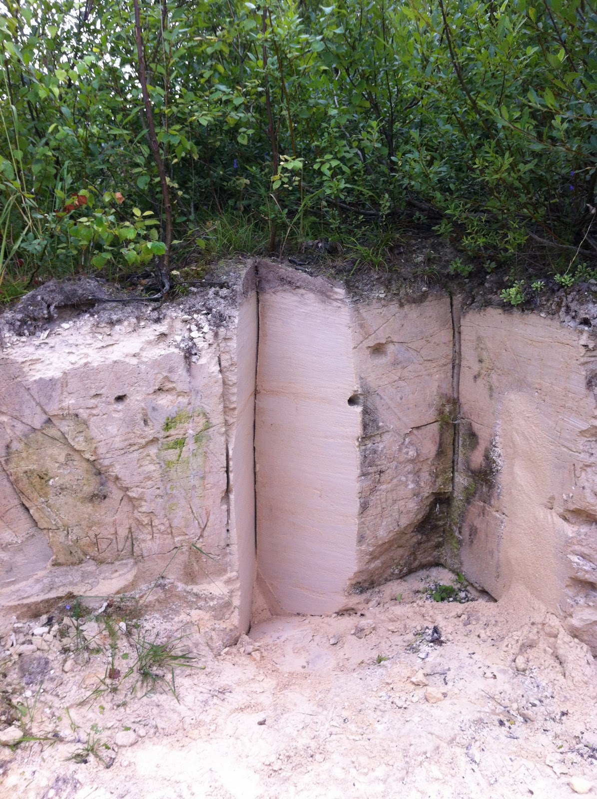
Figure 2: Outcrop of Early Ordovician sandstone and shale (top layer) on the Izhora Plateau. This sandstone contains numerous cross-bed sets that resemble modern beach sediments. Traditionally, this outcrop has been interpreted as a transition from the littoral zone (i.e. 'near the beach') to a lagoonal environment.
Of course, the geological history of this region begins much earlier. Underlain by igneous rocks that comprise the ~3-billion-year-old Baltic Shield, layers of sedimentary rock were deposited between the Late Neoproterozoic (Ediacaran Period) and the Middle Paleozoic (Devonian Period). By and large, these sedimentary rocks—sandstone, shale, and limestone—contain marine or coastal fossils and are typical of a passive margin. For reference, think of the modern southeastern coast of the United States, which gently slopes into the Atlantic and Caribbean seas and is now accumulating fine-grained sandstone and limestone with marine fossils.

Figure 3: Outcrop of Devonian carbonate rocks on the shore of Lake Ilmen. Several layers are very rich in marine molluscs (see Fig. 10), providing evidence to their depositional environment.
If you live in the western U.S. or Canada, you may already be familiar with this geological sequence. There, Late Neoproterozoic to Middle Paleozoic sedimentary rocks overly very old granite and granodiorite (2.7–1.8 billion years old). These rocks comprise the "basement" of western states from Idaho/Nevada to Montana/Wyoming. Hence the geological record in Idaho, for example, is quite similar to that of northwestern Russia.

Figure 4: Modern view of the Izhora Plateau. This summer vegetation conceals not only a diverse geological history, but a ~6,000-year record of human activity from ancient Finno-Ugric tribes to warring Scandinavian peoples to the Noble settlements of Imperial Russia to the front lines of the Siege of Leningrad.
The rock records of both the western U.S. and northwestern Russia are explained geologically by modern analogs of coastal environments, along with the theory of Plate Tectonics. The spreading of ancient seas (not unlike the modern Atlantic) is a major long-term control on subsidence and relative sea level. Subsidence refers to the 'sinking' of crustal rocks with respect to sea level as 1) the basement rock cools with time to become more dense, and 2) accumulating sediments add weight to the crust, which is essentially 'floating' on the mantle. Slow rates of subsidence (on the order of millimeters per decade) allow for the accumulation of marine sediments on the edges of large continents over long periods of time.
Figure 5: Nearly hidden outcrop of Ordovician limestone in a small depression formed by recent tectonic activity.
Figure 6: Closeup of features in the outcrop above. A) Clear view of brittle deformation in the limestone. According to the Young-Earth timeline, these rocks must have been deformed only a few hundred years after being deposited (during the "Post-Flood Ice Age"). Yet by the time of deformation, the lime sediments must have been completely cemented and lithified to form such brittle fractures. Unfortunately for the YEC, deeply buried, water-saturated sediment does not behave like fresh-laid concrete in the driveway. The proposed timeline is rather preposterous. B) Abundant trace fossils of organisms living in shallow marine waters. C) These burrows reach up to ~1 foot in length and run horizontally through the rock. Horizontal burrows are typical of arthropods that feed in the shallow sediment. In other words, these are not tracks of organisms desperately trying to escape during a catastrophic flood. Else where are the all the critters themselves?
Since subsidence rate is the ultimate control on sedimentation rate, one can begin to understand why the sedimentary record seems so 'patchy' and why sedimentary contacts (including unconformities) are often so 'flat'. If high-energy weather events or even local catastrophes (e.g. tsunamis) deposit large quantities of sediment in the shallow sea, more common forces like waves, tides, and gravity work diligently to flatten out the seabed. Part of the event (fossils included) will get preserved in the rock record, while the majority is 'washed out to sea'. In other words, it is entirely possible to bury organisms and sediment forms rapidly in a 'uniformitarian' setting (Fig. 6).

Figure 7: Purely for scenery; view of the small lake adjacent to the outcrop above. Although crystal clear, the lake is devoid of animal life because... (below)
Figure 8: The spring that feeds into the lake is relatively rich in radon—a harmful, radioactive gas produced by the decay of Uranium and Thorium. These elements occur naturally in all sediments, but concentrate in silt/clay layers like those bounding the aquifer that feeds the spring. As the Orthodox cross indicates, this spring is considered a local holy site by those whose health benefited greatly from drinking here. Contradictory as that may seem, drinking purified mineral water with a bit of radon is far more healthy than ingesting the swampy waters of the Neva River, polluted by sewage and agricultural runoff.
Quaternary sediments lie directly on top of Paleozoic rock (Devonian or older) in this region. Whatever geological events transpired in northwestern Russia between the Devonian and the Pleistocene may ever be a mystery to us. Not because the geologic column is a sham, as YEC's like John Woodmorrape spuriously claim, but rather because sediments from those intervals have been wiped away from the continent (we know this partly because their remains are found among Quaternary 'debris', but also because rocks from that period are present in other parts of Russia). The mechanism responsible was driven by climatic events that dominated the latter half of the Pleistocene. During this time, the Russian landmass was already situated in high latitudes of the northern hemisphere and provided a foundation for advancing sheets of ice.

Figure 9: Immediately overlying Ordovician rock (Fig. 2), this layer of till marks the most recent advance of the Scandinavian Ice Sheet (Fig. 12). Note the conglomeration of clasts—of every size, flavor, and age—within a silty mud matrix. This structure is typical of glacial deposits.
Figure 10: Glaciers make strange (sedimentary) bedfellows. These clasts come originally from all parts of Fennoscandia (the granite at the upper right is Finnish), while some are local. The shelly, red rock in the center, for example, is derived from a Devonian limestone marker bed (seen in Fig. 3).
As the global climate cooled repeatedly by more than 10°C, these ice sheets grew up to several thousand meters thick and literally 'bulldozed' whatever laid in their path. Some rocks were even ground into fine powder and deposited in lakes and river beds that formed in front of the wall of ice. Under the weight of the massive ice sheet, the entire north-Eurasian landmass was compressed and downwarped. The downwarping caused many Paleozoic rocks to be folded and fractured. It was so extreme that parts of Scandinavia have rebounded in elevation more than 500 meters since the disappearance of the ice (to which modern fjords provide stellar visual examples), and are still 'recovering' today.

Figure 11: From Svendsen et al. (2004). Cross section of glacial deposits across Fennoscandia and northwestern Russia, including tills and interglacial sediments from the past ~150,000 years. Note the vertical exaggeration in the scale (200 m per 200 km). In reality, this picture is 1,000 times flatter.
The process of glacial advance and retreat occurred numerous times during the Pleistocene and often bulldozed sediments from previous glaciations. This raises a good question: if earlier sediments were lost, how do we know how many ice ages occurred and when? The answer lies in marine sediments and ice cores, whose fossils and water molecules have been analyzed for oxygen isotopes. The ratio of 18O to 16O in marine shells (foraminifera) reflects the volume of ice on land, while same ratio in glacial ice (e.g. in Antarctica and Greenland) reflects global temperatures. Both values are plotted on the Quaternary timescale, which I referenced earlier. The fact that these records agree with each other and with records on land (such as from caves and lakes, or the timing of glacial tills) provides multiple lines of independent corroboration for the conventional geological timescale. On the other hand, the  YEC is hard pressed to explain these multiple records through a "post-Flood ice age" that lasted only several hundred years. What controlled 18O in each record so that any kind of agreement is possible? Their rationalizations of the evidence (e.g. "Where does the ice age fit?") often sweep away geochemical data by calling it "statistically questionable" (an irrelevant accusation given the dynamic elements that control each recorded process) and focus on interpretive difficulties raised by glaciologists over the years (which have since been solved, but few YEC readers would ever investigate this on their own). Young-Earth authors posit that a single ice sheet advancing multiple times could explain the record of glacial deposits—not because they can test this claim independently, but rather to escape having to deal with the details of Quaternary stratigraphy. How, for example, did warm-weather marine and continental sediments (filled with plants/animals like those seen today) get deposited between glacial tills (peach-colored layer in Fig. 11)? Talk about rapid climate change!

Figure 12: Maximum extent of the most recent ice sheet over northern Eurasia.
In North America, the last ice age is called the Wisconsin glaciation—named after the locality that marks its maximum extent. The same period is called the Valdai glaciation in Russian terminology. Thus my tour ended up in the Valdai Hills, which are home to the terminal moraines of the last glacial maximum.

Figure 13: Hills? Yes, technically, or even 'uplands', but not as I'm used to in the western U.S. Nonetheless, these few hundred meters of relief on the Russian plain give birth to multiple rivers that water the Baltic plain on one side and the Caspian and Black seas on the other. This includes the largest river in Europe: the Volga.
Figure 14: View of Lake Valdai, a remnant of the glacial landscape, from the bridge connecting an island monastery (below) to the mainland.
About 14,000 people live in the city of Valdai—a popular vacation spot and home to many summer cottages (including one that belongs to Mr. Putin). Even the Fall scenery of this cozy settlement has much to offer, in my opinion, despite the constant rain and slightly 'chilly' weather.

Figure 15: View of Lake Valdai from the northern shore; Iverskiy Monastery visible on opposite shore.
Figure 16: Main cathedral of Iverskiy Monastery.
In the mid-17th century, construction of Iverskiy Monastery took place by order of the Patriarch Nikon. The main cathedral (Fig. 16) was built in only two summers and closely resembles the architectural style seen elsewhere in Russia during this period. With the exception of the Soviet era, the monastery has functioned since the 1650's. As I recall from the tour, this plot of land survived in part because it was used as a recreational camp for Soviet youth. Regardless, renovation of the various cathedrals, clerical living quarters, dining hall, hospital, and towers has been ongoing since 1991, when the property was returned to the Orthodox church.

Figure 16: Who doesn't love a good mushroom hunt? They say all mushrooms are tasty, but some only once. 

Figure 17: I didn't take my chances with this mushroom either...
 After touring the monastery, we managed to take a relaxing walk through the hills adjacent to the lake. For me, the stark contrast in vegetation to my childhood in Coloradan forests was most exciting. Here, the forest floor is soft and thick, full of ferns and other plants that simply don't grow in such arid conditions. It may sound strange—well, it is—but I also did not understand the concept of a "mushroom hunt" until now. These things grow everywhere, and quite large!

Figure 18: Pines shape the canopy like small skyscrapers. The recovery of pine forests occurred relatively quickly in this region in the latest glacial period (between ~14–12.5 thousand years ago; Bølling-Allerød warming phase), marking the transition to a warmer, wetter climate.

Figure 19: Tread lightly. The floor of this marsh lies several feet beneath what only looks like grass.
As the Scandinavian Ice Sheet advanced toward Valdai, the constant melting of ice at its margin produced torrents of sediment-choked streams. Modern sandurs, or glacial outwash plains, are best known from Iceland. They are dynamic landscapes that are reshaped constantly by deposition of sediment that was eroded from the continent and locked up in the ice. Sandurs are preserved in the geological record as thick beds of cross-bedded sand and gravel (Figs. 20–22), due to braided rivers that sweep across the plain in front of the glacier. In fact, the weight of the glacier often forms a ridge many miles in front of the ice (imagine stepping on a floating log to raise the opposite end) that keeps these rivers flowing parallel to the ice margin rather than away from it.

Figure 20: The poorly sorted cross-bed sets that comprise the upper layer likely formed in migrating channels of water before the glacier. Horizontally bedded sand in the lower unit, which lacks much of the gravel component seen above, is more typical of the plains between major channels. In other words, these successive layers record two fluvial (river) environments that were adjacent to each other.
Figure 21: More of that horizontal bedding, though with some coarser grained beds. One can imagine the high energy of flow and massive amounts of water being dumped into the basins at this time.
Figure 22: Closer view of channel cross bedding; very typical of modern braided streams.
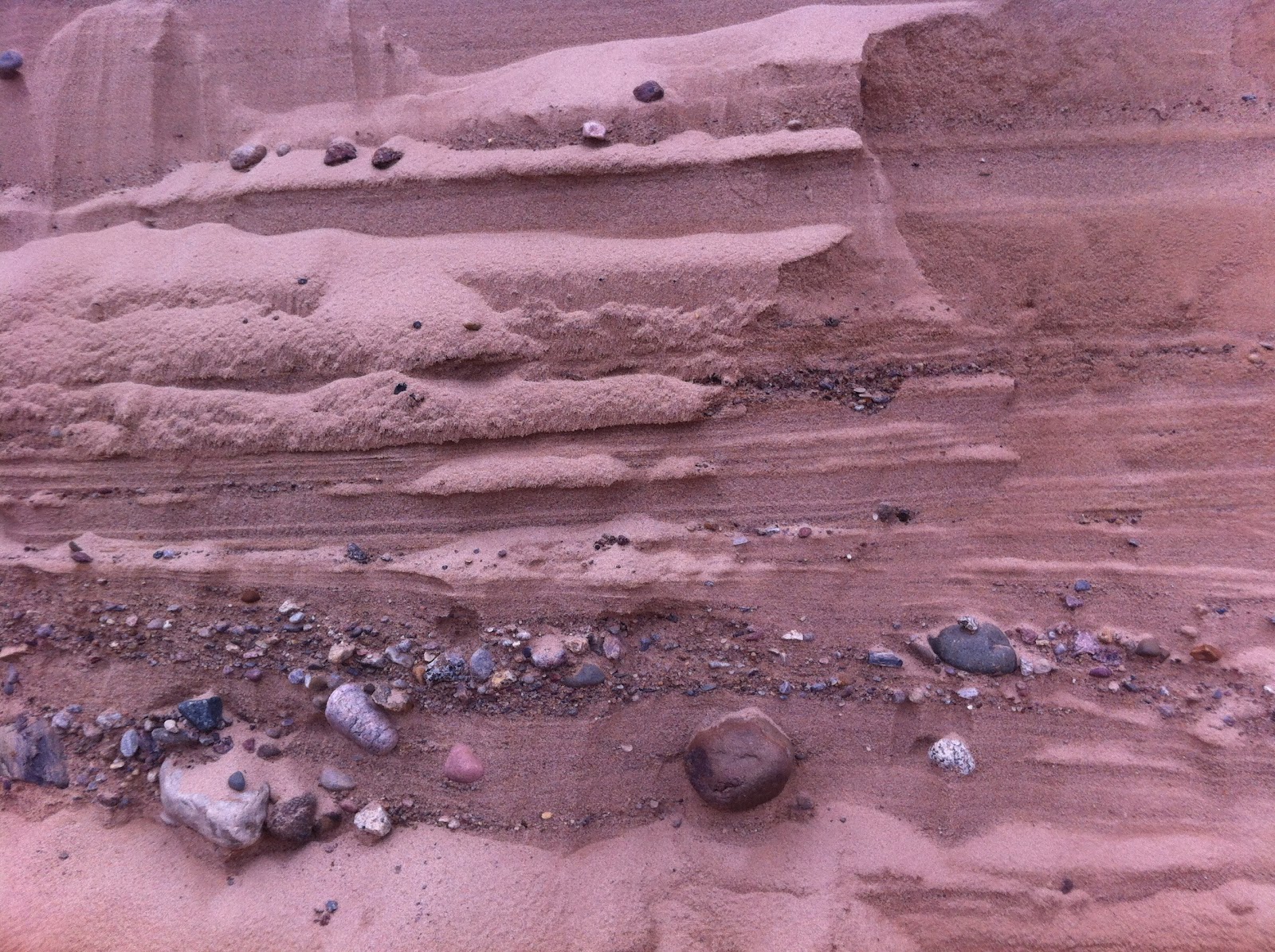
Figure 23: This monstrous anomaly cuts through periglacial sediments pictured above. The larger clast size denotes much higher energy flow, and may resemble a proglacial stream that eroded previously deposited sediments as the glacier retreated. The orange color is from goethite and limonite—iron oxide minerals that tightly bound the clasts.
As the Scandinavian Ice Sheet began to melt and recede from the landscape, it left clear evidence of its path. Numerous lakes formed in depressions left by the ice. Erratic boulders carried hundreds of kilometers by the ice now dot the surface. Well, it's not unlike any other glacial landscape, I suppose. But it was my first experience with such landforms and deposits in person!

Figure 24: An erratic boulder, given that its granitic composition cannot be found in this region. This particular traveler came from Finland via a massive conveyor of ice and now rests on top of morainal sediments, which themselves overlie the sandur deposits pictured above. The full sedimentary sequence thus marks the advance, halt, and retreat of the last major glaciation in northern Eurasia.
Figure 25: Varved clay sediments deposited in ancient Lake Ilmen (northwest of Valdai), which has since decreased in volume significantly. The darker layers represent winter deposition, while the lighter bands represent summer deposition. This lake is called proglacial, because it formed in front of the ice as the ice sheet retreated.

Figure 26: If you have seen varves before, these layers may seem a bit thicker than normal. The reason is that the lake was fed at this time (Late Glacial period) by melting ice, which contained abundant quantities of clay-rich sediment that was scraped from the land surface during the glacier's advance.
Figure 27: When clay accumulates 'quickly', it retains excess water that somehow must escape. These minor folds in the varves (called load structures) are evidence of that escape.
Thus far we covered the bedrock stratigraphy from St. Petersburg to Valdai, which recorded deposition between the Ediacaran and Devonian periods in a passive marine margin. After that, we looked at Late Glacial deposits in and around the Valdai Hills region. In the second part, I'll post pictures from along the glacier's retreat (Lake Ilmen back to St. Petersburg) and discuss some of the Holocene changes that took place in northwestern Russia.

Feel free to post questions or comments below regarding any of the pictures and discussion.