Well, I did not intend to wait two weeks to finish this story, but a trip to Moscow—among other responsibilities—delayed my getting back to the topic. I am still amazed at how quickly time moves here!
During the early stages of the Holocene, the climate became substantially warmer until the Holocene Climate Optimum, about 6,000 years ago (or 16 years after creation, by YEC reckoning). One question that remains is how atmospheric circulation responded to warming in this region, and whether warming was accompanied by wetter or drier conditions. Carbonate lake sediments (Figs. 19–20) formed on the Izhora during the first half of the Holocene and may provide some clues.
And thus ends my brief geological tale—scattered and disorganized perhaps as the political history of Russia. I will leave you only with two eerie markers of a more recent 'upturning' near the Izhora Plateau. Like those great sheets of ice, remnants of the Russian Revolution are ubiquitous and unmistakeable. That advancing wave erased some memories in favor of others and left much of the political and economic landscape bare, yet still fertile for growth and new ideas. Attitudes toward that era are still mixed among the populace, but it shaped this region no less than the walls of ice that preceded it by more than 20,000 years.
In this post, I want to finish the timeline by discussing how this region of Russia transitioned from ice age to the modern warm period. If you are interested in how the story beings, please see Part 1 in my previous post.
Around 21,000 years ago, the Scandinavian Ice Sheet extended to the hills of Valdai (Fig. 1), where morainal (Fig. 9; last post) and proglacial sediments are still found at the surface. Thus it is no surprise that the modern topography—its plains, ridges, lakes and rivers—are defined entirely by the advance and degradation of this monstrous block of moving ice. And yes, it is vital to emphasize that glacial is constantly moving, albeit at inches per year.
As a result, the Earth's surface is scratched, twisted, or smoothed out (Fig. 2) while the ice sheet samples rocks and sediments across its entire journey, much like an obsessed traveller stopping at every gift shop for representative collectibles. In fact, some of the more successful attempts to estimate the average chemical composition of the Earth's crust merely involved analyzing clays that accumulated at the edge of glaciers. Glaciers are nature's most meticulous geologists, in that sense.
Continental glaciers begin to retreat when the ice at their margin melts faster than ice can accumulate in higher latitudes. In other words, melting glaciers are not like stagnant ice cubes left out in the sun, but continue to flow even as they disappear. For northern Eurasia and Fennoscandia (as in North America), the disappearance of such ice took some 10,000 years, just to give you an idea of the volume of freshwater added to the continent. During the transition from the Late Glacial period to the early Holocene (~14,000–9,000 years ago), the climate of northern Eurasia also became substantially warmer and wetter. The contribution of glacial ice, melting permafrost, and enhanced precipitation was sufficient to raise the water levels of the Black Sea and Caspian Sea by tens of meters. In northwestern Russia, numerous lakes and rivers now fill depressions that formed under and between lobes of glacial ice, though most lakes have decreased in area since the Late Glacial period. Lake Ilmen (above and below) is a prime example.
Lake Ilmen basin developed in a proglacial setting, where it was fed by water and sediment from the ice sheet to the north. That Lake Ilmen was once much larger is evidenced by banded (varved) clay formations that extend far beyond the modern lake margin (Figs. 25-27, last post). Overlying these clays, stratigraphically, are thin-bedded sandy sediments that reflect a shallowing of the lake as the landscape and climate further evolved. During the Late Glacial period (14,000–11,500 years ago), the level of Lake Ilmen fluctuated in response to oscillating ice sheets, brief cooling and drying of climate, and the formation of a 'pre-Volkhov' channel that caused the lake to drain below modern level about 13,000 years ago.
Pollen and spores collected from these sediments tell their own story of lush forests and grassy meadows, which quite literally sprouted from the barren ground shortly after it melted. The relative abundance of pollen from grasses, herbs, and trees in lake sediments very precisely reflects the temperature and humidity of the surrounding region. By collecting pollen and spores from each layer, therefore, one can interpret how climate changed over time. As you might imagine, stratigraphic shifts in pollen abundances closely follow lake level (cold vs. warm climate), as well as oxygen isotope records from the North Atlantic ocean (also indicative of cool vs. warm climate). These records also generally agree with those from caves and loess in Eastern Europe, peat and lake formation in the Baltic region, and other proxies on land. Geologists and paleogeographers use these tools to reconstruct past climate changes region by region, as well as to deduce physical causes behind such changes.
It is a curious challenge for the YEC, therefore, that proxies for Pleistocene and Holocene climate agree so well, given that each is dated by various methods (Radiocarbon, U-series, OSL, ESR, Beryllium-10, etc.) and reflects different geological processes. It is possible that in NW Russia, for example, a shift in pollen abundance from cold-weather herbs to an dominance of pine and oak trees (a sign of warmer and wetter climate) was not due to changing climate over thousands of years, but is rather an artifact of sediments from various regions being washed into a single lake basin (remember, the Flood can accomplish whatever one wants it to). I have heard YEC's argue in this manner, but one should ask: why does the radiocarbon method, applied to several dozen lakes in Russia alone, date this transition (which happened across Eurasia and North America) to approximately the same time period? Furthermore, why does the oxygen-isotope composition of calcite (from marine shells, carbonate lakes, or caves) record a similar transition at the same time, as defined by a completely different dating method (U-Th)?
Put more simply, if radiometric dating doesn't work, then why does it work so well?
The physical theory by which dates from each method are interpreted from raw data have only time in common in their equations. In other words, there is no physical explanation besides the passage of time to explain why radiocarbon and Uranium-Thorium dates should agree with each other, since each dating method reflects a completely different process (the accumulation of radioactive carbon in the atmosphere versus the accumulation of thorium in crystalline calcite). The most parsimonious explanation is the one most commonly given: global and regional climates changed dramatically over the course of several thousand years during the transition from ice age (~21,000 years ago) to a warm early Holocene (~11,000 years ago).
 |
| Figure 1: Map of northwestern Russia with sites of interest, and geographical and political boundaries. Major water bodies are the Gulf of Finland at the top left and Lake Ladoga at the top right. The city of St. Petersburg (Санкт-Петербург) is located on the delta of the Neva River, which feeds the gulf from the east. |
 |
| Figure 2: Valley lowlands outside of Velikiy Novgorod, where a few thousand feet of ice flattened the landscape and left it bare. |
 |
| Figure 3: Southern coast of Lake Ilmen; view from atop the glint (limestone escarpment; see Fig. 3, last post). |
 |
| Figure 4: Rocky shoreline of Lake Ilmen, which includes erratic boulders from northern granites. |
 |
| Figure 5: Northwestern shore of Lake Ilmen. The lake itself covers a shallow depression, visible also by low-gradient shorelines on the northern edge. Between rainy and drought years, the area of the lake fluctuates by more than a factor of two. |
 |
| Figure 6: A brief detour (fish on the Ilmen shore): contrary to YEC claims, it is possible to collect specimens for fossilization in sediments accumulating at modern rates. This half-buried fish (not to mention an abundance of shells) is a common site on lake shores, as scavengers are more interested in meat than bones. On the shore of the Great Salt Lake, I've even seen an entire bird skeleton buried under a few centimeters of lime sediment, which solidifies rather quickly. If this process was responsible for the bulk of fossils currently found in the geological record, then we might still predict that preservation is a rarity. But that is a far cry from "impossible" outside of "catastrophic conditions". |
 |
| Figure 7: Mouth of the Volkhov River, which connects Lake Ilmen to Lake Ladoga (another geomorphological remnant of the ice sheet). View from St. George Monastery—the oldest in Russia—in Velikiy Novgorod. |
The physical theory by which dates from each method are interpreted from raw data have only time in common in their equations. In other words, there is no physical explanation besides the passage of time to explain why radiocarbon and Uranium-Thorium dates should agree with each other, since each dating method reflects a completely different process (the accumulation of radioactive carbon in the atmosphere versus the accumulation of thorium in crystalline calcite). The most parsimonious explanation is the one most commonly given: global and regional climates changed dramatically over the course of several thousand years during the transition from ice age (~21,000 years ago) to a warm early Holocene (~11,000 years ago).
 |
| Figure 8: Ducks! But not entirely unrelated to the glacial story. As ice melts from the land, many tons of pressure leave with it. This often cracks the frozen ground, forming new paths for groundwater to reach the surface. Highly mineralized water still bubbles to the surface and is the fount for this popular health resort at Staraya Russa, where Dostoevsky himself wrote part of The Brothers Karamazov and found inspiration for one of its characters. |
 |
| Figure 9: Speaking of groundwater, this artesian aquifer was tapped accidentally by the advancing German army in World War II, when a shallow well pierced the overlying aquitard. Just west of Novgorod, this creek and a nearby monument to local Soviet soldiers mark the occasion's solemn memory. |
And on to Velikiy Novgorod, which recently celebrated its 1153rd birthday. Novgorod is one of the oldest cities in the Russian territory, though it was not annexed to Russia officially until the reign of Ivan the Terrible (16th century). Novgorod owes its economic success to the process of deglaciation some 14,000 years prior. The numerous rivers that now feed or drain Lake Ilmen connect the Gulf of Finland/Baltic Sea to the Black Sea and the Caspian Sea—not to mention every city in between. This made Novgorod an ideal spot for Medieval tradesmen and merchants. Until the past few centuries, Novgorod rivaled cities like Paris, both economically and in terms of population. Even the peasants of Novgorod enjoyed a relatively high standard of living up through the Imperial period. I highly recommend this spot to any of you travelling to Eastern Europe, not only for its historical sites and architecture, but for the natural beauty that surrounds it.
 |
| Figure 10: In the "Square of Seven Churches", this one alone reveals the original brickwork. The original date of construction escapes me (13th century?), but the preservation is outstanding nonetheless. For most of its history, stone construction was not allowed in Novgorod except for churches. For that reason, the city burned down multiple times—well, all but the cathedrals. |
 |
| Figure 11: Main bridge and gate to the Kremlin at Novgorod. Two more outer walls protected the city, as well as this innermost citadel, from invaders. This stronghold was also known as the "Detinets" (Детинец), which may also refer to the fetus of a mother. Fortunately, these walls never served a defensive purpose and still stand ~1,000 years later. The Novgorod Kremlin is also home to the oldest cathedral in all of Russia: St. Sophia's (follow link for more pictures of the cathedral and its art). |
As one follows the retreat of the glacier back toward St. Petersburg, the Izhora Plateau stands out among the absolutely flat landscape. Bound on the north by a cuesta-like escarpment, the plateau diverts major rivers such as the Volkhov that flow north to Lake Ladoga or the Baltic Sea. The faulted and folded landscape of the Izhora Plateau is partially due to glacial sculpting, but much is a result of neotectonic deformation since the earliest stage of the Holocene. As a result, numerous springs flow from the fractured, Ordovician limestone bedrock. The rivers and lakes here are pristine and crystal clear (Fig. 22), while the vegetation is so green year round as to be therapeutic.
 |
| Figure 12: Entrance to a late Medieval fortress on the Izhora Plateau. Originally built by Germanic tribes in the 13th century, the stronghold was 'renovated' by Swedes in the 16th century. |
 |
| Figure 13: The bricks here are derived from local limestone. A closer look would reveal numerous marine fossils from the Ordovician period. Thus construction began long before man tilled the land here. |
 |
| Figure 14: West wall; a daunting view for would-be attackers. |
 |
| Figure 15: View northwest toward the Baltic (from the other side of the tower in Fig 14). Endless forests conceal the rich soil. |
 |
| Figure 16: Up top, you can see that the stronghold is more of a walled, earthen mound. However, I wouldn't complain as a resident... |
 |
| Figure 17: Not part of the original construction, this crumbling Russian Orthodox church reveals how the territory has shifted politically over the years. |
 |
| Figure 18: And finally, a view from one of the defensive posts on the wall. Robin Hood, anyone? |
 |
| Figure 19: Microdetrital carbonate sediments (beige-colored, carbonate sand) are exposed here in a local quarry. This rock had been used for more than 100 years for renovations in St. Petersburg and the surrounding area. Some of the quarried stone was even used to mend Kazanskiy Cathedral. |
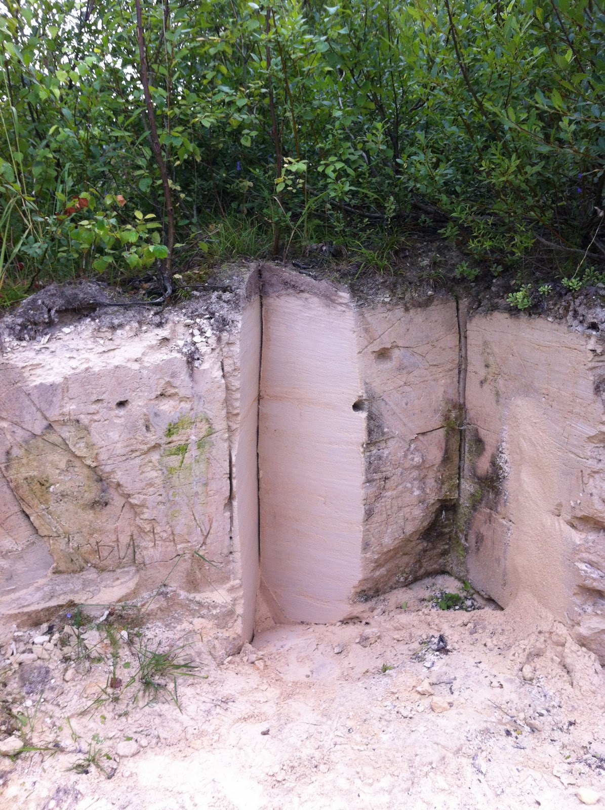 |
| Figure 20: Closeup of carbonate sediments, this time cut for geological sampling. Annual layers are visible even at this distance. These layers formed as lake productivity fluctuated between summer and winter months, much like varves. Numerous shells of molluscs (mostly snails) tell their own story of how lake levels fluctuated during the early Holocene. The lake drained very near or before the Holocene Climate Optimum, and the valley is now cut by the modern Izhora River. |
Although the prior existence of a lake that is no longer there may seem to imply wetter conditions, the formation of the lake actually resulted from structural deformation (small anticlinal folds) that dammed the river—not necessarily from more rain/snow. An alternative hypothesis is that this warm period was accompanied by more frequent anticyclonic circulation, which originates in the Arctic, blocks moisture from the North Atlantic, and causes severe drought. The fires around Moscow in Summer 2010 were the result of such circulation patterns. If future warming increases the frequency of drought, local agriculture may suffer accordingly. According to analyses of instrumental records over the past 250 years, the city of St. Petersburg has warmed by 1°C more than major cities of western Europe. Since the shorter, less productive growing season of Northwestern Russia is more sensitive to drought, this hypothesis needs to be resolved soon.
 |
| Figure 21: Ordovician limestone bedrock, responsible for the topography of the Izhora Plateau, as well as its rich soils. This rock also hosts the cleanest groundwater of the region, including the springs that fed Peter the Great's summer palace. This picture is more for looks than anything, as it strongly contrasts the sort of outcrops I am used to seeing back home. |
 |
| Figure 22: Pristine and crystal clear lakes, as promised. |
 |
| Figure 23: Lenin was far more than a cultural icon here. His image symbolized hope and freedom. |
 |
| Figure 24: For the most part, 'Noble' cottages like this one did not survive the 1917 revolution. With haunting scenes like this one dotting the landscape south of St. Petersburg, that year will long be fresh in the cultural memory. |
 |
| Catching the last train home... |
Photos you shared in this blog is really looking fantastic and nicely clicked. I am glad to read your blog. Thanks for sharing your experience and photos with us. keep posting like this.
ReplyDeleteRussia Tour Packages